


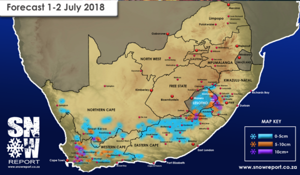
Get ready for another cold front, and this time some snow will accompany the rain. Snow Report SA has forecast snow for the Western Cape as a cold front makes landfall on Sunday. Cold, wet weather, is expected to continue through to the early hours of Tuesday morning and will bring a blanket of snow with it.
Snow will decorate most of the Cape mountain peaks by Sunday evening. Some ranges such as Hottentots Holland, Cederberg, Matroosberg and the Boland mountains are expected to receive as much as 15cm. Areas of the Northern Cape such as Sutherland, Calvinia and Fraserberg can also expect snowfalls.
As the cold front moves East, the Eastern Cape should receive its fair share of snow too, with the heaviest falls predicted for the Lady Grey and Barkly East areas and surrounds. Hogsback is likely to receive a light dusting too.
Expect icy cold temperatures and more rainfall across the country from Sunday until Tuesday morning. The South African Weather Services have issued a warning regarding the cold front. Farmers are urged to prepare their livestock accordingly. Get your warmest winter coat ready because it’s going to be a cold one.
Pictures: Pixabay & Snow Report
