


Living in Cape Town is an extreme sport. The weather is best described as wild and untame. It can turn from sunny skies to cloud cover and rain in the matter of minutes, forcing us all to come prepared with a jacket and umbrella, and a plan to take cover, even during summer.
The last few days have given new power to the Mother City’s nickname, ‘The Cape of Storms’. While Wednesday [September 30] started off warm and bright, a cold front took hold in the evening, bringing rain and a whipping cold wind to many parts of the country.
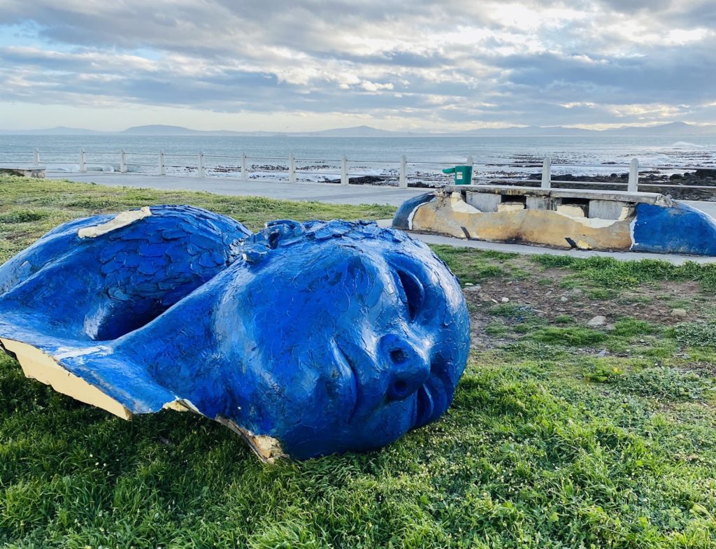
The iconic two blue heads on the Mouille Point Promenade did not survive the storm that lashed the area on Wednesday evening.
The South African Weather Service (SAWS) recently issued a weather warning, explaining a “spell of fairly active weather” is already unfolding, driven primarily by the development of a steep upper trough over the western and south-western parts of the country. This will bring severe or extreme weather phenomena in the coming days.
“Over the Western Cape, cold, overcast and windy conditions with heavy rain and localised flooding will dominate the circulation pattern. Moreover, marine gales and high sea conditions will also affect much of the Western Cape coastline,” they warn.
According to Afriwx Southern Africa Weather, Rainfall & Storm Reports, there is even the possibility of snow throughout the country. “The rainfall you see on Wednesday through Friday across the central interior and though the Northern, Western and Eastern Cape into Western KwaZulu-Natal is largely expected to be snow and mixed rain/snow,” they write on their Facebook page.
Whenever anything big happens in the city, Capetonians do what they do best: make a joke of it. Locals have turned to social media to poke fun at the wind and rain that has dominated this week.
South Africa: “YAY it’s Spring”
Cape Town weather: “spRinG” pic.twitter.com/Ol67Lad2ji
— Phumzile Van Damme (@zilevandamme) October 1, 2020
The result of the storm in Cape Town last night …. #CapeTown pic.twitter.com/afLlmZPfOq
— Liezel V ? (@liezelv) October 1, 2020
I feel like #capetown #rain runs on Internet Explorer and only recently started responding again after someone hit refresh 3 years ago.#weather #delayed
— JP (@jdam_za) September 30, 2020
Cape Town weather & constantly reminding you that you’re single ??
— Yeza. (@Sakhile_15_) September 30, 2020
Cape Town weather, while the rest of the country is knee deep in December: pic.twitter.com/vZqd7JQTX7
— Candice Modiselle (@CandieModiselle) September 30, 2020
Cape Town has Karate Kid weather jacket on one moment the next jacket off
???
— I’m Drea?. (@AndreaSharel) September 29, 2020
lol Cape Town weather is really like a man , you can’t confirm it
— Kayla (@KaylaIndiana) September 30, 2020
Cape Town weather for you is ridiculous. You can have all the seasons in 1 day?
— LockDean*? (@_TheBoss) September 28, 2020
Picture: Liezel van der Westhuizen
