


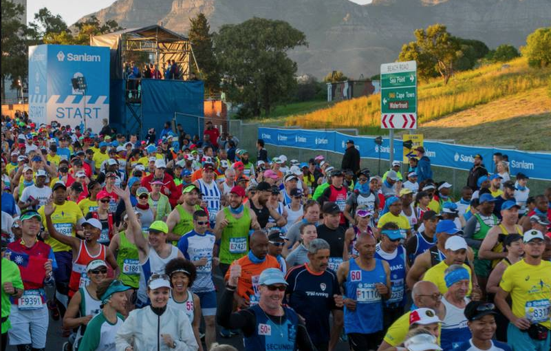
The Sanlam Cape Town Marathon is one of the country’s great sporting highlights, with over 20 000 participants expected to hit the streets on Sunday 23, Septemeber 2018. This will include athletes from all over the world.
Running the marathon is unique way to experience the gorgeous highlights and the vibrant spirit of one of Africa’s most visited and celebrated cities. It is an ideal race both for athletes who aim to achieve fast times and for first-timers who want to finish their inaugural marathon.
The route is also wheelchair-friendly, and the 6 hour 30 minute cut-off time will accommodate social runners too.
The marathon has issued a warning that public transport services and driving routes may be congested on the day of the race, and may also in some cases become inaccessible.
It is advised that additional travelling time must be accorded as there may be severe delays.
The main transport impact:
Certain roads within the Atlantic Seaboard, CBD and suburbs (including Woodstock, Salt River, Observatory, Mowbray, Rondebosch, Newlands and Claremont) will be closed from 3am to 13:30pm.
MyCiti, GABS bus routes and City Sightseeing bus routes will also be affected in certain areas.
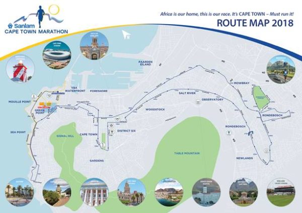
KEY ROAD CLOSURES
Beach Road (both carriageways) will be closed from Haul Road through to Queens Circle from 06h00 – 09h30; it will be managed in phased approach – to detour via Main Road.
Queens Circle / Queens Road / Regent Road / Church Road is closed from 6am to 07.35am
Beach Road between Queens Circle and Clarens Road / Beach Road is closed from 6am to 07.35am
Beach Road City Outbound Carriageway between Queens Circle and Rocklands Rd is closed from 6am – 8am
Beach Road City Outbound Carriageway between Rocklands Rd and Three Anchor Bay, lane closure from 6am – 9am
Beach Road City Inbound Carriageway is closed from 6am – 9.15am.
Alternative routes:
Traffic travelling from Clifton will enter Sea Point on Victoria Road (M6); they will turn right into Queens Road; left into Kloof Road, left into Church Road to Regent Road; right into Regent Road onto Main Road (M61). (Note – Beach Road & balance of Regent Road is closed).
Traffic travelling from Sea Point through to Clifton will enter via Main Road (M61); they will take the left fork into Kloof Road; turn right into Fir Ave and left into Victoria Road (M6).
HELEN SUZMAN INBOUND CARRIAGEWAY will be closed from Beach Rd to Buitengracht Street [06h30 – 08h15]
Traffic entering the City to use Somerset Road as alternative
LONG STREET: LONG STREET between Hans Strijdom and Orange Street will be closed. This includes all intersections with Long Street. [06h30 – 08h45]
Alternative routes:
Citybound traffic travelling from N2 to enter City through Hertzog Blvd, left / right into Adderley to exit via same route.
Citybound traffic travelling from Camps Bay to exit left into Somerset Road; right into Ebenezer, right into Dock Road and to enter via Walter Sisulu Ave, to exit via same route. (note: Long Street intersection of Strand will be closed from 6.45am – 12.45pm).
TENNANT ROAD closure: Tenant Road will be closed at the Darling / Sir Lowry intersection. [6.40am – 9.15pm]
Alternative routes:
Southbound traffic on Christiaan Barnard wanting to cross Sir Lowry via Tennant to detour via Hertzog to N2, to Keizergracht Street via the Searle Street offramp.
Northbound traffic on Tennant wanting to cross Sir Lowry to Christiaan Barnard will detour via Keizergracht onto the N2 at the Searle Street onramp, to the Strand or Hertzog off-ramps.
SIR LOWRY / VICTORIA CITYBOUND CARRIAGEWAY – SIR LOWRY / VICTORIA CITYBOUND CARRIAGEWAY from Tennant all the way through to N2 will be closed. [6.40am – 9.50am].
This includes all cross-over to/ from all mountainside intersections including Searle Street, Mountain Road, Fairview Ave, Roodebloem Road, Browning Road and Anzio Road.
Alternative routes:
Traffic will be able to enter the area:
From the city via Sir Lowry Road.
From the N2 (airport-bound) via Liesbeek Parkway to Station Road.
From the N2 (city-bound) via Main Road offramp to Lower Main Road via contraflow.
Traffic will be able to exit the area:
To the city via New Market Street.
To the N2 (airport-bound) via Main Road.
To the N1, via Main Road, N2 (airport-bound), M5 to N1.
To Claremont via Main Road and Claremont Blvd.
MAIN ROAD closure: Citybound Carriageway will be closed from N2 all the way through to Protea Bridge in Claremont from [6.55am – 10.30am] This includes all cross-overs of main road intersections including Rhodes Ave, Woolsack Drive, Grotto Road, Klipper Road & Dean Street.
Alternative routes – north of N2:
Traffic will be able to enter the area:
From the city via Main Road.
From the N2 (airport-bound) via Liesbeek Parkway contraflow to Durban or Belmont Road.
From the N2 (city-bound) via Main Road.
Traffic will be able to exit the area:
To the city via Liesbeek Parkway onto the N2 (city-bound) or via Main Road, Claremont Blvd, Protea Road and the M3.
To the N2 (airport-bound) via Main Road, Claremont Blvd and Protea Road to the M3; or via Belmont, Liesbeek Parkway contraflow to the N2 (city-bound), then the offramp onto Main Road and loop back to the N2 (airport-bound).
To Claremont via Main Road to Claremont Blvd.
CAMPGROUND ROAD closure: East and Northbound Carriageways from Main Road to Keurboom & Keurboom to Park will be closed from 7.5am-10.55am. This includes all cross-overs to or from mountain side roads and intersections to Campground Road.
Alternative routes:
There will be limited access to St Thomas Church, Bishops College, Spar, Caltex and Shell filling stations via Belmont interchange and contra-flow on Campground Rd.
Residents can exit or enter area via White, Myrtle, College and Queen to Belmont Road to Main for Claremont or for Liesbeek contraflow to N2.
SANDOWN ROAD: Eastbound Carriageway from Campground Rd to Wood Rd will be closed from 7.15am – 11.25am. This includes all cross-overs of Sandown.
Alternative routes:
Westbound access is open, access to Campground Road is limited to only Claremont direction. Use Avenue de Mist or Keurboom Rd as route to M5
Traffic exiting side roads into Sandown Road, from the south of Sandown Road, can turn left only and exit via Sandown – Campground – Keurboom into Milner Road
Traffic exiting side roads into Sandown Road, from west side to exit via emergency exit in Jamieson Road to Milner.
PARK, MILNER, KLIPFONTEIN & SAWKINS ROAD closure: Park Road (both Carriageways), Milner Road (Northbound Carriageway), Klipfontein Road (From Liesbeek Parkway to Milner Rd) and Sawkins Road will be closed from 07h20 – 11h40
Alternative routes:
Traffic wanting to access Liesbeek Parkway from Klipfontein Road, Milner Road or Raapenberg Road to detour via the N2 to Main Road to Durban Road.
Traffic wanting to access Klipfontein Road and Milner Road from Liesbeek Parkway or Durban Road to detour via Liesbeek to the N2, left to Main Road, where they can U turn and re-enter the N2 and access the M5.
Milner Road (Southbound Carriageway) will be a contraflow
LIESBEEK & MALTA ROAD – LIESBEEK & MALTA ROAD from N2 to Station Road Southbound Carriageway will be closed from 7.35am – 12.30pm
Alternative routes:
Traffic will be able to enter area
from City via Sir Lowry Road,
from N2 Airport bound via Liesbeek Parkway to Station Rd
from N2 Citybound via Main Road off-ramp to Lower Main Rd via contraflow
Traffic will be able to exit area
to City via New Market Street,
to N2 (Airport-bound) via Main Road,
to Claremont via Main Road, via Claremont Blvd
LOWER CHURCH STREET – Lower Church Street / Beach Road / Albert Road will be closed for the period 07h45-13h00 on Sunday 23rd September 2018. The off-ramps from the N1 to the Lower Church Street & Lower Church Street will be closed.
Alternative routes:
Traffic wanting to access Woodstock from N1 Traffic wanting to use the N1 off-ramp City inbound, will be deviated via the CBD, Christian Barnard Street to Main Road and Woodstock.
Traffic wanting to use the N1 off-ramp City outbound will continue to M5, N2 and enter Woodstock via Main Road to Lower Main Rd contraflow.
Traffic wanting to exit out of Woodstock to the N1 from Albert Road can exit via Main Road onto N2, M5 to N1. From 09h15 they can deviate via Searle onto N2, M5 to N1.
Beach Road will only be able to exit this area onto the N1. There is no access via Albert Road
ALBERT ROAD / NEW MARKET STREET – ALBERT ROAD / NEW MARKET STREET closure from Lower Main Road to Adderley Street Eastbound Carriageway will be closed from 07h35 – 13h00, this includes all cross-overs from side roads and intersections (sea side) with Albert Road. It includes Salt River Circle (no access to Voortrekker Road) and Lower Church Street (no access to or from N1)
Alternative routes:
Access to Salt River from Voortrekker Road via Koeberg Road, Blackriver Parkway, N2, Main Rd to Lower Main Rd;
Access to Maitland from Voortrekker Road via Main Road, the N2 and Blackriver Parkway.
There will be controlled access to businesses in Voortrekker Road from Maitland side.
Traffic will be able to enter area
from City via Sir Lowry Road,
from N2 Airport bound via Liesbeek Parkway to Station Rd
from N2 Citybound via Main Road off-ramp to Lower Main Rd via contraflow
Traffic will be able to exit area
to City via New Market Street,
to N2 (Airport-bound) via Main Road,
to the N1, via Main Road to N2 (airport-bound), M5 to the N1
to Claremont via Main Road, Claremont Blvd
STRAND STREET: STRAND STREET Eastbound Carriageway will be closed between Hans Strijdom and Orange Street from 8am – 12.45pm.
Alternative routes:
Traffic travelling from upper Cape Town wanting to access the foreshore / lower side of Cape Town to detour from Adderley, Loop or Bree Streets via Wale or Strand onto Buitengracht and then back into Riebeek Street to access the lower part of the City.
Traffic travelling from the foreshore or lower parts of Cape Town wanting to access upper Cape Town to detour from Long or Bree Streets via Riebeek Street, or from Adderley via Adderley Street Fountain Circle into Hans Strijdom where they will turn left into Buitengracht, left into Wale Street to access upper Cape Town.
Traffic / buses to exit Grand Parade via Castle Street; Sir Lowry Street to Christiaan Barnard to Hertzog offramp onto N2.
FULL ROAD CLOSURE DETAILS
For full road closure details go to http://www.capetownmarathon.com/information/road-closures/
Picture: Facebook
