
While September is well on its way and spring flowers are blooming across the Cape, yet another cold front is set to make its way through the Western Cape this weekend, according to the South African Weather Service (SAWS).
Also read: The best places to see wildflowers in the Western Cape
With the cold front expected to make landfall in the south-western Cape on Friday morning, 15 September, the weather service said residents should once again brace for strong to gale-force winds, rainy conditions, light mountain snow, rough seas and very cold temperatures in various parts of the province.
As a result, SAWS has issued a series of impact-based weather warnings for varying durations over the weekend:
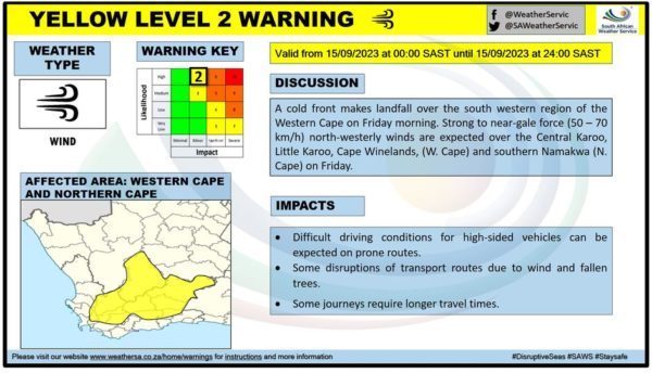
Yellow level 2 – wind
A Yellow level 2 warning for damaging wind has been issued as strong to near-gale force (50 to 70kph) north-westerly winds are expected over the Cape Winelands as well as the Central Karoo and Little Karoo on Friday.
SAWS warned that these conditions may result in difficult driving conditions for high-sided vehicles as well as some disruption of transport routes due to wind and fallen trees.
The weather warning is valid from 12am to midnight on Friday, 15 September.
Cape {town} Etc discount: Looking for things to do in the city, at half the price? Get exclusive offers here.
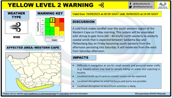
Additionally, a second Yellow level 2 for strong winds was issued for the province’s coastal regions.
The weather service said strong to gale-force (60 to 80kph) north-westerly to westerly coastal winds associated with the cold front are expected between Saldanha Bay and Plettenberg Bay on Friday, becoming south-westerly in the afternoon and persisting into Saturday.
SAWS added that these conditions will moderate from the west from Saturday afternoon and may result in localised disruptions to beachfront activities, small harbour and ports, localised build-up of sand and difficulty in navigating small vessels and personal watercraft.
The weather warning is valid from 12am on Friday, 15 September, until midnight on Saturday.
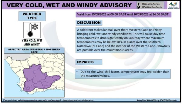
Very cold, wet and windy advisory
The weather service also issued an advisory for very cold, wet and windy conditions over the Western Cape that will be in effect from 12am on Friday, 15 September, until midnight on Saturday.
According to the advisory, the cold front will cause daytime temperatures to drop significantly on Saturday, when maximum temperatures can be expected to drop to below 10ºC in places over the interior of the Western Cape.
SAWS added that some mountainous areas may experience some snowfall.
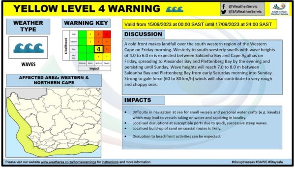
Yellow level 4 – waves
A Yellow level 4 warning for strong and high waves has been issued as strong to gale-force winds (60 to 80kph) accompanying the cold front contribute to very rough and choppy seas.
SAWS said westerly to south-westerly swells with wave heights of four to six metres are expected between Saldanha Bay and Cape Agulhas on Friday. These conditions are set to spread to Alexander Bay and Plettenberg Bay by Friday evening and will persist until Sunday.
The weather service added that wave heights will reach seven to eight metres between Saldanha Vay and Plettenberg Bay from early Saturday morning into Sunday.
The weather warning is valid from 12am on Friday, 15 September, until midnight on Sunday.
Explore Cape Town and its surroundings with these incredible deals on cars for under 100k. Find car listings here.
Also read:
Picture: Kenny Eliason / Unsplash