
The South African Weather Service (SAWS) issued a report detailing “bitterly cold conditions” for large parts of South Africa from Thursday and into the weekend. Snowfall as deep as five centimeters can be expected over the eastern high-lying areas of the Western Cape.
Here’s the full report:
A steep upper-air trough system will develop into a cut-off low pressure system over the north-western interior of the country by Friday, 20 May 2022. Widespread rainfall can be expected over the southern and central parts of the country from Thursday onwards, with light snowfalls likely over the mountainous, high-lying areas of the Western and Eastern Cape, spreading to the Lesotho Drakensberg regions by the weekend, where heavier falls are anticipated. Light snowfalls can also be expected over the high-lying ground of south-eastern and eastern Free State.
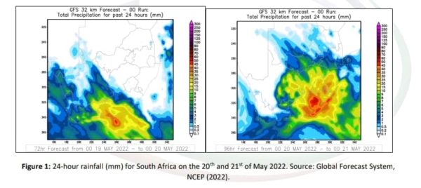
24-hour rainfall accumulations of 25 to 35 millimeters can also be expected over the drought-stricken parts of the Eastern Cape. Moreover, there is also the possibility of isolated severe storms, accompanied by strong winds and large amounts of small hail over the central and eastern interior, however SAWS says it will issue detailed radar-based warnings in this regard, should the need arise.
Figure 1:
Wednesday’s warm weather (due to offshore Berg wind conditions) signalled the oncoming of a cold front over the south-west coast of the Western Cape, with rain spreading along the south coast and adjacent interior that evening. These conditions were accompanied by gusty winds of 45-55 km/h over the interior and south coast of the Western Cape as well as the interior of the Northern Cape.
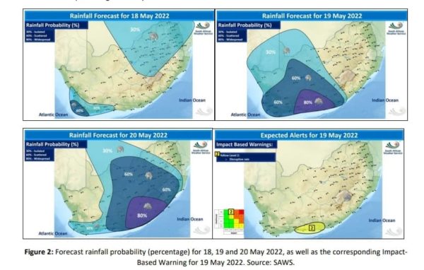
The upper-air trough will intensify during Thursday, causing widespread rainfall over the eastern parts of the Western Cape and the western parts of the Eastern Cape. A Yellow Level 2 warning for disruptive rainfall, resulting in localised flooding of susceptible roads and bridges as well as flooding in informal settlements can therefore be expected in the aforementioned areas, spreading to the central and south-eastern parts of the Eastern Cape during Thursday.
Figure 2:
Due to the lowering of atmospheric freezing levels, combined with abundant moisture in the lower layers of the atmosphere, snowfalls as deep as 2 to 5 centimeters can be expected from Thursday night over the eastern high-lying areas of the Western Cape, spreading to the western high lying areas of the Eastern Cape, the extreme south-eastern high-lying areas of the Northern Cape and the southern high ground of the Free State during Friday morning.
Heavier snowfall of 10 to 20 centimeters can be expected over the north-eastern high ground of the Eastern Cape, the Drakensberg region of KwaZulu-Natal and the Lesotho mountains from Friday evening into Saturday morning.
Thunderstorms, combined with strong, gusty surface winds are expected over the central interior by Friday afternoon, spreading to Gauteng, Mpumalanga and KwaZulu-Natal in the evening and parts of Limpopo by Saturday. Warnings in this regard will be issued if necessary, says SAWS.
Due to the pre-existing condition of water-saturated soils in parts of KwaZulu-Natal, rainfall amounts exceeding 20 millimeters are likely to lead to localised flooding. It is therefore important for communities to take the necessary precautions to prepare for such conditions.
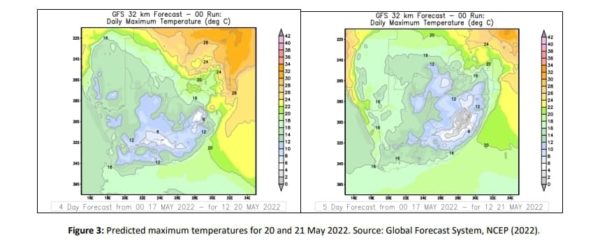
Bitterly cold conditions are expected to move in over the western and southern parts of the country during Thursday, spreading to the central and eastern parts by Friday and Saturday. Maximum temperatures are not expected to exceed 14°C over the interior of the country, with maximum temperatures barely able to reach 8°C over the high-lying areas of the Eastern Cape, the south-western high ground of KwaZulu-Natal and the south-eastern and extreme southern Free State during Friday and Saturday. Small stock farmers should be advised of these conditions and take the necessary precaution.
Figure 3:
The South African Weather Service says it will continue to monitor any further developments relating to this weather system and will issue subsequent updates as required. Furthermore, the public are urged and encouraged to regularly follow weather forecasts.
Shark spotted on the Keurbooms River, public urged to exercise caution
Picture: Unsplash