


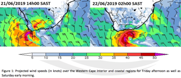
Locals are advised to be careful when leaving the house on Friday, June 21 as an intense cold front will hit the Western Cape in the morning. As predicted by the South African Weather Services (SAWS), strong westerly to northwesterly winds with speeds of between 40 and 60 km per hour will usher in the cold front.
“Moreover, gale force winds can also be expected in places over the Central Karoo, Breede River Valley districts and Cape Peninsula. Gale force winds associated with the passage of the cold front are also anticipated on Friday along the coast between Table Bay and Plettenberg Bay,” SAWS said in a statement. “These strong, gusty winds may result in damage to settlements and infrastructure, transport routes and travel services being affected by falling trees, blowing dust as well as strong crosswinds, which could lead to longer travel times, as well as closure of susceptible and key routes.”
Rain is also expected to arrive in the Western Cape around midday on Friday, and will spread inland and eastward across majority of the province. Deluges of between 20 and 30mm are predicted to fall, while mountainous areas can anticipate showers of between 40 and 50mm.
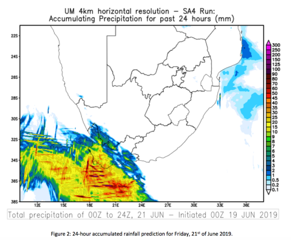
“Periods of heavy downpours may occur, which could lead to localised flooding. Informal settlements on the Cape Flats and the Overberg District are likely to be amongst the areas most vulnerable to flooding. Snowfalls are also likely over the southern mountains of the Western Cape on Friday night to Saturday morning,” the service said.
High seas exceeding six metres are expected to reach the southwestern coast of the Western Cape by Friday evening, spreading eastwards and reaching the southern coast of the Eastern Cape as far east as Port Elizabeth by Saturday morning.
Weather conditions are expected to deteriorate dramatically, posing a significant risk to life.
“On Saturday rain and showers will persist along the south coast and adjacent interior of the Western Cape, spreading to the Eastern Cape by the evening. The public can also expect cold to very cold temperatures to set in over the southwestern parts (including the Western Cape, Northern Cape, the northern and south western interior of the Eastern Cape and south western Free State) on Saturday,” SAWS said. “As the cold front shifts to the northeastern part of South Africa on Sunday, showers can be expected along the southeastern and eastern coastline, together with cold to very cold conditions over a large part of the interior of the country, where heavy frost can be expected Sunday night.”
The public should take heed of the following watches issued by the South African Weather Service:
1. Heavy rain is expected over Cape Winelands, Overberg and Cape Metropole of the Western Cape on Friday
2. Localised urban flooding is expected over Cape Winelands, Overberg and Cape Metropole of the Western Cape on Friday
3. Strong to gale force winds are expected over the Central Karoo District, Breede River Valley and along the coastal regions between Cape Point and Plettenberg Bay on Friday, spreading to Port Alfred and the adjacent interior on Saturday
4. High seas with wave heights in excess of six metres are expected between Cape Point and Cape Agulhas on Friday evening, spreading towards Port Elizabeth on Saturday morning.
In addition, there is an advisory for very cold conditions (daytime temperatures less than 10°C) in the southern Namaqua district of the Northern Cape as well as the Cape Winelands and Central Karoo regions of the Western Cape on Saturday.
Picture: Pixabay
