


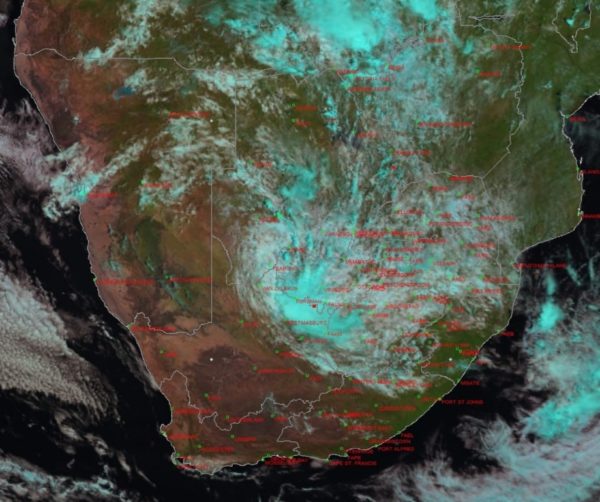
Storm Eloise made landfall in Beira, Mozambique on Saturday, January 23 and has left an extensive trail of destruction along its path over Mozambique as well as the north-eastern parts of South Africa.
Ex-Eloise is now a much-weakened extratropical low-pressure system and is currently situated over the south-western parts of Botswana.
According to the South African Weather Service (SAWS), the Free State, North West province and the north-eastern half of the Northern Cape will experience adverse weather conditions for the remainder of the week as a result.
“A cold front will slip past the country during Wednesday, January 27, 2021. The arrival of the cold front will herald a linkage of weather systems, between the tropics and the extra-tropical regions. Such a juxtaposition of weather systems can typically be expected to contribute towards heavy rainfall over the central interior as the weather system moves from west to east and this case will be no exception,” said SAWS in a media statement.
“Our numeric weather prediction (NWP) models are indicating significant amounts of rainfall to occur over the eastern parts of the Northern Cape, western parts of both the North-West Province and the Free State. It is anticipated that this rainfall, associated with a broad band of showers and thundershowers will move slightly eastwards by Thursday, January 28, 2021. This will likely contribute to a drier day for the eastern parts of the Northern Cape, with the possible exception of the extreme north-eastern parts of last-mentioned region.”
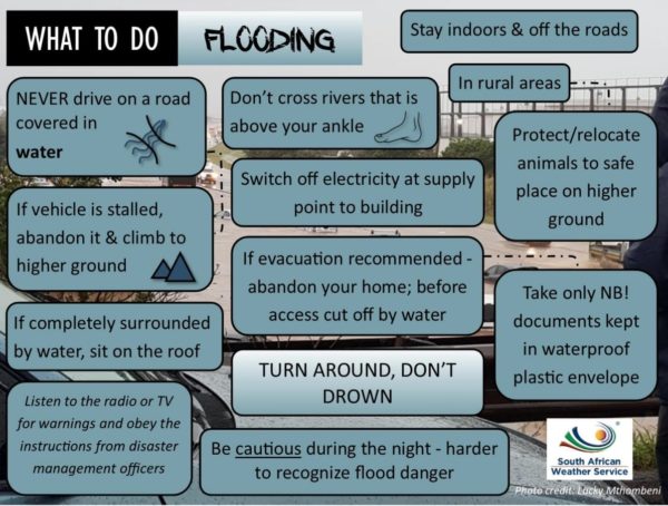
SAWS has issued the following warnings for disruptive rainfall valid from Tuesday afternoon, [January 26] until Friday evening [January 29]:
– Yellow warning for disruptive rainfall expected over the western parts of the North-West Province and the extreme north-eastern parts of Northern Cape on Tuesday, resulting in flooding of low-lying areas, disruption to traffic and basic services as well as damage to crops and livestock.
– Yellow warning for disruptive rainfall expected over the western parts of the North-West Province and the extreme north-eastern parts of Northern Cape, spreading to the western and central parts of Free State by Wednesday, resulting in flooding of low-lying areas, disruption to traffic and basic services and damage to crops and livestock.
The following impacts associated with disruptive rainfall can be expected:
– Localised/flash flooding of low-lying areas, informal and formal settlements.
– Impaired agricultural production due to flooding and damage to crops.
– Difficult driving conditions (major- and dirt roads) due to reduced visibility and flooding of roads which can contribute to minor vehicle accidents and increased travel time.
– Disruption to essential services (e.g. power cuts, network issues, interruption of water supply to smaller towns).
– Vulnerable communities adjacent to floodplains and riverbeds should be on high alert should river levels rise, causing flooding of communities and settlements. This can ultimately lead to displacement or evacuation of such communities at short notice.
– Danger to life: The public are strongly urged to refrain from crossing flooded streams or rivers by vehicle or on foot.
Picture: Pexels
