


About 39 roads in the Western Cape remain inaccessible due to the severe storm that caused considerable destruction over the Heritage Day long weekend.
The intense rainfall resulted in significant damage due to flooding, mudslides, rockfalls, fallen trees and damage to buildings and infrastructure, as well as the disruption of services.
Also read: CoCT mayor declares destructive storm a major incident
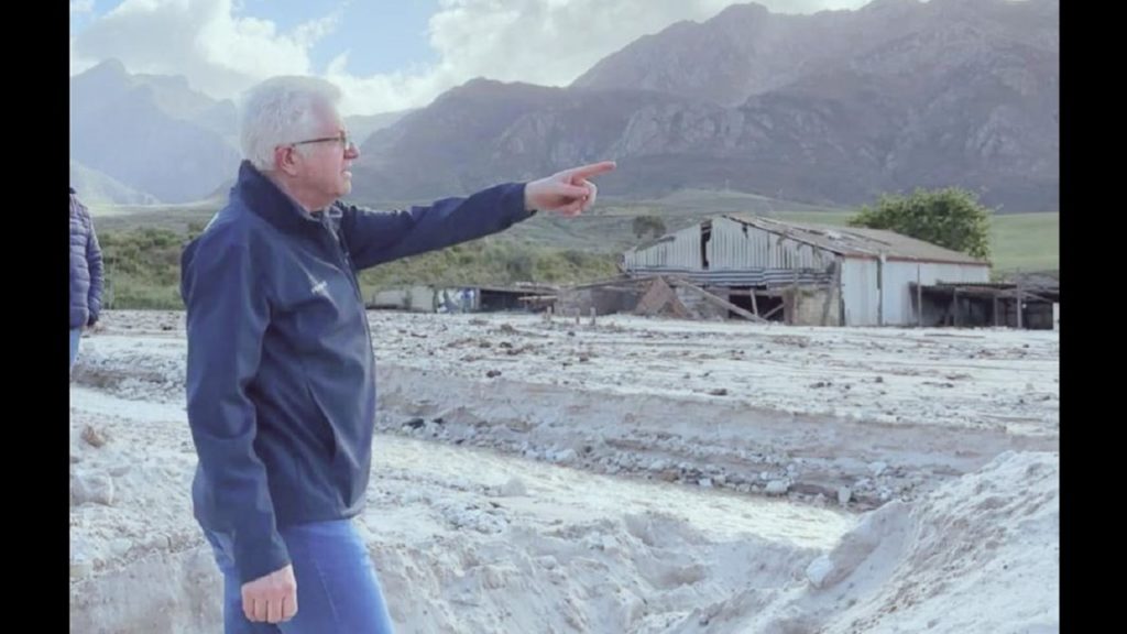
Western Cape Premier Alan Winde provided a brief update on the ongoing clean-up efforts and the condition of major roads in the province.
He mentioned that while some road closures were partial with stop-and-go systems in operation, others remained entirely closed.
Winde emphasised that there were no quick and easy solutions to the road damage issue. He advised that it’s essential to ensure that the ongoing road repairs are capable of withstanding similar severe weather conditions in the future.
Engineers are inspecting areas, like Botrivier, where the N2 is currently closed, that still need time to dry out before conducting a thorough assessment.
The following roads remain closed:
City of Cape Town
- Chapman’s Peak closed
- Baden Powell lane closure
Cape Winelands District Municipality
- MR290 (B3062) McGregor approach: bridge structure washed away
- MR191 Franshoek Pass closed, severe slips and erosion
- DR01347 Doringrivier, water overtopping road surface
- OP05671 Moddergat, water overtopping road surface
- OP05662 De Hoek, water overtopping road surface
- DR1400 Nuy Km 6.70 Road closed water overtopping
- DR1353 Konings River km7.80 water overtopping road
- DR1360 Roodekleigat
Overberg District Municipality
- TR 29/2 Nagwag Bridge between Bredasdorp and Arniston, local access for
bakkies and SUVs. - DR1254 Karwyderskraal Road near Botriver closed
- DR1271 Swartvlei Road: alternative route also closed
- DR1288 Van der Stel Pass Road closed
- De Mond reserve cut-off
- MR269 Hemel and Aarde Road (DM currently working on their section)
- R44 (TR27/1) Clarence Drive – closed from Grill Shack towards Rooi Els
- OP4037 Klein Transvaal
- DR1263 Malgas Pont out of service
Helderstroom/Genadendal/Greyton area gravel roads
- DR1298 Middelplaas Road: Closed 5km outside of Genadendal (km 20 to
Km 21) – Alternatives available - DR1294 N2 to Greyton closed from the N2 for 7km
- DR1308 Ouplaas closed
- DR1313 & DR1311 (Helderstroom and between Greyton and
Riviersonderend)
Tesselaarsdal area gravel roads
- DR1257 Southern access road from R320 closed
Garden Route District Municipality
- DR1615 Karatara overtopping
- TR59 Prince Alfred Pass
- DR1783 Gouna River overtopping
- DR1650 Kammanasie River overtopping
- TR2/12 Bloukrans km 36 (Closed from N2)
Central Karoo District Municipality
- Moordernaarskaroo roads are wet and sustained more damage
- R353 between Leeu Gamka N1 and Prince Albert (MR373) river overtopping
- MR370 Klaarstroom to Willowmore
West Coast (update on these roads may have changed)
- R2161 (Versveld Pass) between Piketberg and Piket-bo-berg
- DR1161 Morreesburg Gouda Road
- Uitkyk Pass further damages
- DR1487 (Dwarsriver farm) km45
- DR2182 km9, Cederberg, Algeria to Clanwilliam
Minor roads in the vicinity of the Berg River
- Olifants River low water bridge
- MR530 0-1.2 Bergriver over flowed (Veldrift area)
- DR1147 2-3 km Darling-Marme
- OP800710-2.77 (Porterville-bo-berg)
- DR1154 km 5 (Sonkwas – Riebeeck Kasteel)
- OP7608 (Moravia)
- OP7605 (Broodkraal)
- OP7623 (Sandrif)
- OP7626 (Klipbank)
- OP7763 (Caledonia – Hopefield area)
- Olifants low water bridge (N7 Algeria turn off)
- DR2182 (Algeria/ Clanwilliam /Cederverg)
- DR2189 Clanwilliam
- OP7605 Broodkraal bridge washed away
- MR546 Km51.35 Lutzville low water bridge overtopping
- OP2213 Water overtopping
Cape {town} Etc discount: Looking for things to do in the city at half the price? Let these great offers inspire you and fuel your imagination! Get them here.
Also read:
Cape storm flood impact study identifies most-affected towns
Picture: Premier Alan Winde / Facebook
