


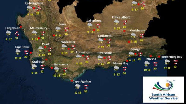
The SA Weather Service (SAWS) has released the weather forecast for the Western Cape today, when the province can expect to experience a cloudy day with some thundershowers.
Also read: Heavy rainfall causes flooding on Main Road in Kalk Bay
A Yellow level 3 weather warning for disruptive rain that could cause flooding has been issued.
Flooding of roads and settlements can be expected, along with significant disruptions to traffic and essential services, in parts of the province.
Damage to property, infrastructure and livestock is also possible due to mudslides and rockfalls.
This comes as a well-developed cut-off low-pressure system is expected to bring widespread showers and thundershowers over most of the Western Cape today.
The Overberg, Cape Winelands, and Central Karoo can expect significant rainfall, with heavy downpours occurring within a short space of time later this morning.
In the afternoon, very isolated severe thunderstorms are likely in the aforementioned areas.
Last week, heavy rainfall caused flooding on the M4 Main Road and the M75 Clairvaux Road and motorists were advised to exercise extreme caution and maintain vigilance.
As the rain continues, motorists must prioritise their own and others’ safety by taking necessary precautions while driving. Maintaining a safe following distance is strongly advised, and drivers should turn on their headlights to improve visibility.
Cape {town} Etc discount: Looking for things to do in the city, at half the price? Get exclusive offers here.
Also read:
Picture: Pexels
