


The wet winter season seems to have arrived in Cape Town in full force – the city’s CBD has received nearly 40mm of rainfall in the past 48 hours and more is in store. Two cold fronts hit the city and the greater Cape just a few days between one another, and some areas received up to 73mm of rain.
Although the rest of the week is predicted to be clear, a 53% chance of precipitation is on the cards for Cape Town on Monday, June 10. More rain is also expected from Wednesday, June 12 to Thursday, June 14, with a 56% and 60% chance of precipitation on each day respectively.
Figures provided by SAWS show the amount of water that fell between 8am on Tuesday, June 4 to 8am on Wednesday, June 5.
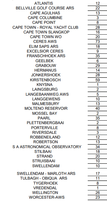
The areas in the Cape that received the most rain were Ceres with 73mm, Kirstenbosch with 59mm, Molteno Reservoir located on Table Mountain with 40mm, and the Cape Town CBD with 39mm.
Although there is no doubt the Western Cape needs this ample rainfall, flooding has affected several areas in the province.
“Disaster Management officials has completed assessments in informal settlements in Khayelitsha, Strand, Gugulethu and Crossroads. Approximately 700 structures has been affected. Plastic sheeting to fix leaking roofs has been issued. No evacuations or emergency sheltering has been activated,” The City said in a statement on Wednesday evening.
This recent deluge managed to reach some of Cape Town’s biggest dams. The Steenbras dam facilities received almost 30mm from the downpours. However, Berg River dam is likely to be the biggest beneficiary this week, following Franschhoek’s reading of 35mm.
Picture: Unsplash
