
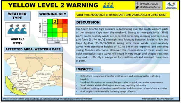
Many a time on media outlets and the South African Weather Service (SAWS) Facebook page or website, headlines and posts contain words like ‘Yellow level 2’ or ‘disruptive rains’ when referring to upcoming weather conditions.
But what do these colours and numbers actually mean and how do they relate to the weather? SAWS explains all in a Facebook post.
Also read: Reconstruction of the Citrusdal access road has started
As a means of warning the general public of possible impacts of hazardous weather, the Impact-Based Severe Weather Warning System was born.
‘It marks the departure from communicating “what the weather will be” to “what the weather will do”,’ explains SAWS.
To communicate this, SAWS makes use of a colour-coded and numbered risk matrix to determine the warning level.
he colours range from green and yellow to orange and red, with green indicating minimal to minor impacts and yellow indicating minor to significant impacts. Orange points to significant and severe impacts, with red indicating the highest level of severe impacts.
The numbers range from 1 to 10 and denote the likelihood of weather-based impacts occurring. Levels 3 and 7 may indicate significant and severe impacts, but they also indicate that the likelihood of occurrence is very low.
Levels 4 and 8 signify a low likelihood, while levels 1, 5 and 9 point to a medium likelihood. The high likelihood of weather-based impacts is represented by levels 2, 6 and 10.
All in all, the colour-coding and the numbering are determined by combining the level of impact with the likelihood of the impact occurring.
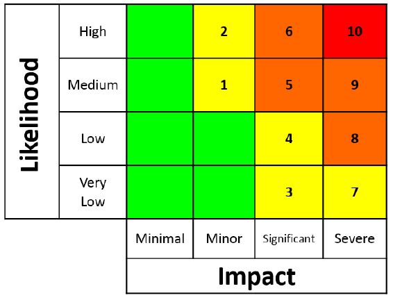
‘For instance, a red level 10 Impact-Based Weather Warning denotes a high likelihood of a severe impact whereas a yellow level 3 warning points to a very low likelihood of a significant impact,’ continues SAWS.
Cape {town} Etc discount: Nachos and milkshakes for two people at Byconcept Cafe for R199 (valued at R248). Get it here.
There are a number of hazardous conditions that SAWS issues weather warnings for, such as disruptive rain, strong and damaging winds and waves, severe thunderstorms, disruptive snow and so forth.
The Impact-Based Severe Weather Warning System is the result of a collaboration between SAWS and the National Disaster Management Centre (NDMC), who are in constant communication as soon as there is a possibility of hazardous weather.
‘A very good example of this relationship was during what has been called the “CapeStorm”. The forecasters first notified the disaster managers of the strong winds a week before the actual storm hit,’ said SAWS.
Leading up to the storm, meetings were held where heads of emergency responders were briefed on possible impacts, and action plans such as closing schools for the day were based on these weather warnings.
‘The idea is to warn the public of the looming danger as early as possible so that they can take precautions and ready themselves for such weather events with a view to saving lives and property,’ concludes SAWS.
Need a new car to weather any storm? Check out these incredible car deals, all priced under 100k. Find car listings here.
Also read:
Picture: Jaco Marais / Gallo Images